Article courtesy of Defiance Development and Visitors Bureau
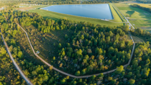
Photo of Reservoir Trail courtesy of Williams Aerial
Located in the heart of Northwest Ohio, Defiance County is home to many national, state, and locally recognized walking trails. Whether you are a seasoned hiker or just looking to take a stroll, all experience levels will enjoy the outdoor amenities along each path. Below are five land and one water trail but there are many other smaller trails for your hiking enjoyment. We encourage you to put hiking in Defiance County on your bucket list.

Defiance Reservoir & Walking Trails, 1261 Precision Way, Defiance, Ohio
The Reservoir Nature Trail is an 8-foot wide, multi-use trail extending from the Defiance Reservoir parking lot through approximately 2,500 feet of natural wooded area. It connects to the “lower” pathway around the municipal reservoir. This walkway offers opportunities for recreational uses such as bird watching, leaf-peeping, or just enjoying quiet walks through nature.
The “upper” trail is a 1¼ mile stone walkway around the top of the reservoir that provides unobstructed views of the reservoir and occasional waterfowl. Benches are spaced along the walk for relaxing bird watching opportunities.
The Reservoir trails utilize a section of the historical Miami & Erie Canal along Canal Road and connect to the Buckeye trail which, in turn, connects Defiance to the scenic 7-state North Country Trail.
Thoreau Wildlife Reserve, 10485 Haller Road, Brunersburg, Ohio
Thoreau Wildlife Reserve is now open to the public for the enjoyment of nature and its 4 nature trails that highlight meadows, woodlands, wetlands, and old growth forest. The Reserve covers approximately 250 acres with 2 miles of trails.
Thoreau Wildlife Reserve is working with the Audubon Sanctuary Program to encourage blue birds, wood ducks, and mallard ducks to nest on the property. Numerous signs can be found along the trails with reference to the thoughts of H.D. Thoreau who inspired the Reserve.

Oxbow Lake and Wildlife Area, 9 Schick Road, Defiance, Ohio
Oxbow Lake lies 10 miles northwest of the City of Defiance. Fish of interest for anglers include largemouth bass, bluegill, green sunfish, and bullhead.
The Oxbow Lake Wildlife Area is a 416-acre area situated in the glaciated lake plain of Ohio and has slightly rolling topography. Some steep land lies adjacent to Mud Creek, which bisects the area. Large cottonwoods and sycamores are found along Mud Creek. The upland woods consist mostly of oaks and hickories. Migrating shorebirds and songbirds can be observed utilizing the lake edges and woodlots during spring and fall. Other types of wildlife such as tree swallows and great blue herons make Oxbow Lake their home territory for the summer months.
Independence Dam State Park, 27722 State Route 424, Defiance, Ohio
Independence Dam State Park covers 591 acres situated along the banks of the beautiful Maumee River. This park is located approximately 3 miles east of Defiance and offers recreational opportunities including boating access, hiking trails, camping, fishing, scenic drives, and picnic areas. Recently playground equipment has been installed and kayak trials are available. A hiking trail, once the towpath for the Miami/Wabash/Erie Canal, meanders between the old canal and the river for 3 miles ending in Florida, Ohio. This trail offers imaginative trips into the colorful past of Ohio’s canal era.

Buckeye Trail, Defiance County Section
The Buckeye Trail is a 1,444-mile hiking and long-distance trail that loops around the state of Ohio. In 2017, the Buckeye Trail Association named the City of Defiance an official Buckeye Trail Town. The path of the Buckeye Trail enters the southwest area of Defiance County and travels on-road through county roads until it enters the City of Defiance. This section moves from on-road to sidewalk passing tree-lined streets of downtown Defiance and beautiful historic homes of yesteryear. On the north side of the downtown, the path travels past a Johnny Appleseed tribute and parallel to the Maumee River and continues on the newly constructed enhanced shoulder to Independence Dam State Park and past old canal locks until the path reaches the Henry County Line. Be sure to Follow the Blue Blazes.
North Country Trail, Defiance County Section
Defiance is honored to be one section on the longest trail in the National Trails System for the US. The North Country Scenic Trail stretches 4,600 miles across 8 different states traveling from North Dakota to Vermont. The path follows the same as the Buckeye Trail through Defiance County.

Here in Defiance County, we have seen quite the increased interest in hiking, biking, nature watching, and exploring the outdoors. We all look forward to Spring and enjoying all that Defiance County has to offer. We hope you come check it out for yourself! More information on all of our trails can be found at www.visitdefianceohio.com.
Defiance Ohio Trails


